Mekong Delta
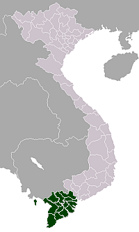
The Mekong Delta (Vietnamese: đồng bằng sông Cửu Long “Nine Dragon river delta”) is the region in southwestern Vietnam where the Mekong River approaches and empties into the sea through a network of distributaries. The Mekong delta region encompasses a large portion of southeastern Vietnam of 39,000 square kilometres (15,000 sq mi).[1] The size of the area covered by water depends on the season.
Contents |
History
The Mekong Delta was likely inhabited long since prehistory; the empire of Funan and later Chenla maintained a presence in the Mekong Delta for centuries.[2] Archaeological discoveries at Oc Eo and other Funan sites shows that the area was an important part of the Funan Kingdom, bustling with trading ports and canals as early as in the first century C.E. and extensive human settlement in the region may have gone back as far as the 4th century B.C.E.
The region was known as Khmer Krom (lower Khmer, or lower Cambodia) to the Khmer Empire, which likely maintained settlements there centuries before its rise in the 11th and 12th centuries.[nb 1] The kingdom of Champa, though mainly based along the coast of the South China Sea, is known to have expanded west into the Mekong Delta, seizing control of Prey Nokor (the precursor to modern-day Ho Chi Minh City) by the end of the 13th century.[nb 2] Author Nghia M. Vo suggests that a Cham presence may indeed have existed in the area prior to Khmer occupation.[nb 3]
Beginning in the 1620s, Khmer king Chey Chettha II (1618-1628) allowed the Vietnamese to settle in the area, and to set up a custom house at Prey Nokor, which they colloquially referred to as Sài Gòn.[3] The increasing waves of Vietnamese settlers which followed overwhelmed the Khmer kingdom—weakened as it was due to war with Thailand—and slowly Vietnamized the area. During the late 17th century, Mac Cuu, a Chinese anti-Qing general, began to expand Vietnamese and Chinese settlements deeper into Khmer lands, and in 1691, Prey Nokor was occupied by the Vietnamese.
Nguyễn Hữu Cảnh, a Vietnamese noble, was sent by the Nguyễn Lords of Huế by sea in 1698 to establish Vietnamese administrative structures in the area.[4] This act formally detached the Mekong Delta from Cambodia, placing the region firmly under Vietnamese administrative control. Cambodia was cut off from access to the South China Sea, and trade through the area was possible only with Vietnamese permission.[2] During the Tay Son wars and the subsequent Nguyễn Dynasty, Vietnam's boundaries were pushed as far as the Cape of Ca Mau. In 1802, Nguyễn Ánh crowned himself emperor Gia Long and unified all the territories comprising modern Vietnam, including the Mekong Delta.
Upon the conclusion of the Cochinchina Campaign in the 1860s, the area became Cochinchina, France's first colony in Vietnam, and later, part of French Indochina.[5] Beginning during the French colonial period, the French patrolled and fought on the waterways of the Mekong Delta region with their Divisions navales d'assaut (Dinassaut), a tactic which lasted throughout the First Indochina War, and was later employed by the US Navy Mobile Riverine Force.[6] During the Vietnam War—also referred to as the Second Indochina War—the Delta region saw savage fighting between Viet Cong (NLF) guerrillas and units of the United States Navy's swift boats and hovercrafts (PACVs).
Following independence from France, the Mekong Delta was part of the Republic of Vietnam and eventually the country of Vietnam. In the 1970s, the Khmer Rouge regime attacked Vietnam in an attempt to reconquer the Delta region. This campaign precipitated the Vietnamese invasion of Cambodia and subsequent downfall of the Khmer Rouge.
Geography
The Mekong Delta, as a region, lies immediately to the west of Ho Chi Minh City, roughly forming a triangle stretching from Mỹ Tho in the east to Châu Đốc and Hà Tiên in the northwest, down to Cà Mau and the South China Sea at the southernmost tip of Vietnam, and including the island of Phú Quốc.
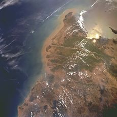
The Mekong Delta region of Vietnam displays a variety of physical landscapes, ranging from mountains and highlands to the north and west to broad, flat flood plains in the south. This diversity of terrain was largely the product of tectonic uplift and folding brought about by the collision of the Indian and Eurasian tectonic plates about 50 million years ago. The soil of the lower Delta consists mainly of sediment from the Mekong and its tributaries, deposited over millions of years as the river changed its course due to the flatness of the low-lying terrain.[7]
Climate change concerns
Being a low-lying coastal region, the Mekong Delta is particularly susceptible to floods resulting from rises in sea level due to climate change. The Climate Change Research Institute at Can Tho University, in studying the possible consequences of climate change, has predicted that, besides suffering from drought brought on by seasonal decrease in rainfall, many provinces in the Mekong Delta will be flooded by the year 2030. The most serious cases are predicted to be the provinces of Ben Tre and Long An, of which 51% and 49%, respectively, are expected to be flooded if sea levels rise by 1 meter.[8]
Demographics
The inhabitants of the Mekong Delta region are largely ethnic Viet, with Khmer minority populations living primarily in the Trà Vinh, Sóc Trăng, and Muslim Chăm in Tan Chau, by An Giang provinces. There are also sizeable Hoa (ethnic Chinese) populations in the Kiên Giang and Trà Vinh provinces.
Provinces
| No. | Provinces/Municipality | Area | Population (2004) | Pop. density | ||
|---|---|---|---|---|---|---|
| (km²) | (mile²) | (persons/km²) | (persons/mile²) | |||
| 1 | Can Tho | 1,401.6 | 541.2 | 1,139,900 | 813.3 | 2,106 |
| 2 | An Giang | 3,536.8 | 1,365.6 | 2,210,400 | 625.0 | 1,619 |
| 3 | Bạc Liêu | 2,584.1 | 997.7 | 820,100 | 317.4 | 822 |
| 4 | Ben Tre | 2,360.2 | 911.3 | 1,353,300 | 573.4 | 1,485 |
| 5 | Ca Mau | 5,331.7 | 2,058.6 | 1,232,000 | 231.1 | 599 |
| 6 | Dong Thap | 3,376.4 | 1,303.6 | 1,667,800 | 494.0 | 1,279 |
| 7 | Hau Giang | 1,601.1 | 618.2 | 796,900 | 497.7 | 1,289 |
| 8 | Kien Giang | 6,348.3 | 2,451.1 | 1,684,600 | 265.4 | 687 |
| 9 | Long An | 4,493.8 | 1,735.1 | 1,423,100 | 316.7 | 820 |
| 10 | Soc Trang | 3,312.3 | 1,278.9 | 1,276,200 | 385.3 | 998 |
| 11 | Tien Giang | 2,484.2 | 959.2 | 1,717,400 | 691.3 | 1,790 |
| 12 | Tra Vinh | 2,295.1 | 886.1 | 1,036,800 | 451.7 | 1,170 |
| 13 | Vĩnh Long | 1,479.1 | 571.1 | 1,057,000 | 714.6 | 1,851 |
Economy
The region is famous as a large rice growing area. It produces about half of the total of Vietnam's rice output. Vietnam is the second largest exporter of rice globally after Thailand.[9] In fact, the delta produces more rice than Korea and Japan altogether. Additionally, the region is home to large aquacultural industry of basa fish, Tra catfish and shrimp, much of which is exported.
The Mekong Delta has recently been dubbed as a 'biological treasure trove'. Over 1,000 new species have been discovered in previously unexplored areas of Mekong Delta, including a species of rat thought to be extinct.[10]
The construction of the Can Tho Bridge, a cable-stayed bridge over the largest distributary of the Mekong River, was completed on April 12, 2010, three years after a collapse that killed 54 and injured nearly 100 workers. The bridge replaces the ferry system that currently runs along National Road 1A, and links Vĩnh Long Province and Cần Thơ city. The cost of construction is estimated to be 4.842 trillion Vietnamese đồng (approximately 342.6 million U.S. dollars), making it the most expensive bridge in Vietnam.[11]
Culture
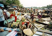
Life in the Mekong Delta revolves much around the river, and many of the villages are often accessible by rivers and canals rather than by road.
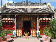
The region is home to cai luong, a form of Vietnamese folk opera.
Notes and references
- Notes
- ↑ "At the height of the Khmer Empire's economic and political strength, during the eleventh and twelfth centuries, its rulers established and fostered the growth of Prey Nokor[...] It is possible that there already had been a settlement at this location in the Mekong marshes for some centuries, depending, as Prey Nokor did, on the handling of goods traded between the countries bordering the South China Sea and the interior provinces of the empire." Robert M. Salkin, Trudy Ring (1996). Paul E. Schellinger, Robert M. Salkin. ed. Asia and Oceania. International Dictionary of Historic Places. 5. Taylor & Francis. p. 353. ISBN 1884964044.
- ↑ "Such a trading center was bound to be one of the prizes in the struggle for power that developed in the thirteenth century between the declining Khmer Empire and the expanding kingdom of Champa, and by the end of that century the Cham people had seized control of the town." Robert M. Salkin, Trudy Ring (1996). Paul E. Schellinger, Robert M. Salkin. ed. Asia and Oceania. International Dictionary of Historic Places. 5. Taylor & Francis. p. 353. ISBN 1884964044.
- ↑ "Saigon began as the Cham village of Baigaur, then became the Khmer Prey Nokor before being taken over by the Vietnamese and renamed Gia Dinh Thanh and then Saigon." Nghia M. Vo (2009). The Viet Kieu in America: Personal Accounts of Postwar Immigrants from Vietnam. McFarland & Co.. p. 218. http://books.google.com/books?id=0oeEpKDCmV4C&lpg=PA13&ots=u66wKiTzO7&dq=The%20Viet%20Kieu%20in%20America%3A%20Personal%20Accounts%20of%20Postwar%20Immigrants%20from%20Vietnam%20By%20Nghia%20M.%20Vo&pg=218#v=onepage&f=false.
- References
- ↑ Mekong Delta on ARCBC (ASEAN Regional Centre for Biodiversity Conservation) site
- ↑ 2.0 2.1 Robert M. Salkin, Trudy Ring (1996). Paul E. Schellinger, Robert M. Salkin. ed. Asia and Oceania. International Dictionary of Historic Places. 5. Taylor & Francis. p. 353. ISBN 1884964044.
- ↑ Nghia M. Vo, Chat V. Dang, Hien V. Ho (2008-08-29). The Women of Vietnam. Saigon Arts, Culture & Education Institute Forum. Outskirts Press. ISBN 1432722085. http://www.sacei07.org/women10.jsp.
- ↑ The first settlers, http://www.hochiminhcity.gov.vn/eng
- ↑ Robert M. Salkin, Trudy Ring (1996). Paul E. Schellinger, Robert M. Salkin. ed. Asia and Oceania. International Dictionary of Historic Places. 5. Taylor & Francis. p. 354. ISBN 1884964044.
- ↑ Dinassaut : French Riverine warfare in Indochina, 1945-1954
- ↑ "Physical and Geographical Features". Mekong River Awareness Kit (Convention on Biological Diversity). http://www.cbd.int/programmes/areas/water/toolkit/html/1.2.0a_physical_geological.html. Retrieved 2010-06-18.
- ↑ Mekong Delta: more flood and drought. VietnamNet Bridge. March 19, 2009.
- ↑ IRRI (International Rice Research Institute) Statistics for 2004-2006.
- ↑ Mekong a 'treasure trove' of 1,000 newly discovered species. Ashley Fantz, CNN. December 16, 2008
- ↑ "SE Asia’s longest cable-stayed bridge underway in Can Tho". September 28, 2004. http://vietnamnews.vnanet.vn/2004-09/27/Stories/02.htm. Retrieved September 28, 2007.
See also
- Greater Mekong Sub-region Academic and Research Network
- GMS Environment Operations Center
- The Journal of GMS Development Studies
- Mekong River
External links
- Mekong Delta travel guide from Wikitravel
- a browsable satellite photo
- PBS
|
||||||||||||||